


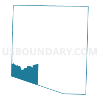
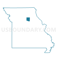
Yates Voting District, Randolph County, Missouri
About
Outline

Summary
| Unique Area Identifier | 609521 |
| Name | Yates Voting District |
| County | Randolph County |
| State | Missouri |
| Area (square miles) | 29.63 |
| Land Area (square miles) | 29.58 |
| Water Area (square miles) | 0.05 |
| % of Land Area | 99.83 |
| % of Water Area | 0.17 |
| Latitude of the Internal Point | 39.33314590 |
| Longtitude of the Internal Point | -92.63224810 |
Maps

Graphs
Select a template below for downloading or customizing gragh for Yates Voting District, Randolph County, Missouri


Neighbors
Neighoring Voting District (by Name) Neighboring Voting District on the Map
- Burton Voting District, Howard County, MO
- Higbee Voting District, Randolph County, MO
- Mt. Airy Voting District, Randolph County, MO
- Prairie Voting District, Howard County, MO
- Salisbury No. 2 Voting District, Chariton County, MO
- Salt Springs Voting District, Randolph County, MO
Top 10 Neighboring County Subdivision (by Population) Neighboring County Subdivision on the Map
- Salt Springs township, Randolph County, MO (2,873)
- Salisbury township, Chariton County, MO (2,504)
- Moniteau township, Randolph County, MO (975)
- Prairie township, Howard County, MO (750)
- Silver Creek township, Randolph County, MO (327)
- Burton township, Howard County, MO (173)
Top 10 Neighboring Unified School District (by Population) Neighboring Unified School District on the Map
- Fayette R-III School District, MO (5,145)
- Westran R-I School District, MO (3,668)
- Salisbury R-IV School District, MO (3,510)
- Higbee R-VIII School District, MO (1,403)
Top 10 Neighboring State Legislative District Lower Chamber (by Population) Neighboring State Legislative District Lower Chamber on the Map
Top 10 Neighboring State Legislative District Upper Chamber (by Population) Neighboring State Legislative District Upper Chamber on the Map
Top 10 Neighboring 111th Congressional District (by Population) Neighboring 111th Congressional District on the Map
Top 10 Neighboring Census Tract (by Population) Neighboring Census Tract on the Map
- Census Tract 4906, Randolph County, MO (5,698)
- Census Tract 9601, Howard County, MO (2,950)
- Census Tract 4703, Chariton County, MO (2,925)